Cross-Country Skiing Experiences at Badger Pass
Badger Pass in Yosemite National Park offers a scenic cross-country skiing experience with groomed and backcountry trails. This article introduces the trail network, ski huts, and the Badger Pass Nordic Center, which provides rentals and guided tours. A map is included to help plan your adventure.
Publish Date: March 3, 2025
Revision Date: March 3, 2025
Yosemite National Park Visitor's Guide is a Trademark.
Copyright © 2025 by Internetpress®
Introduction
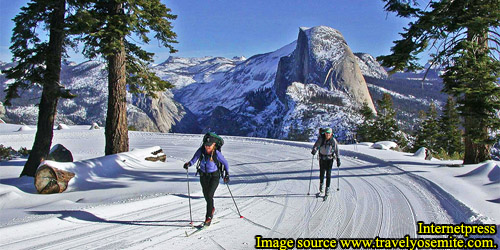
Badger Pass and its surrounding wilderness offer one of the finest cross-country skiing experiences in the country. With 12 designated trails spanning 43.9 miles (70.7 km), this area caters to skiers of all skill levels, from those seeking a leisurely glide through snow-covered forests to those venturing deep into Yosemite’s backcountry. The trails, a mix of groomed and ungroomed routes, provide access to some of the most breathtaking winter vistas in the park. Skiers can take in sweeping views of Half Dome, peer into the depths of Yosemite Valley from its rim, and immerse themselves in the quiet beauty of the high Sierra.
For those looking to extend their adventure, two historic ski huts—Glacier Point Ski Hut and Ostrander Lake Ski Hut—offer rustic overnight accommodations. These backcountry shelters provide warmth and shelter for multi-day excursions, allowing skiers to experience Yosemite’s winter solitude in a truly immersive way.
This article explores the cross-country skiing opportunities at Badger Pass, covering the trail network, trail markings, the Badger Pass Nordic Center, and the ski huts. A detailed map is also provided to help plan your journey through this stunning winter landscape.
Cross-Country Skiing Trail Map of Badger Pass
This section presents the official National Park Service map of the cross-country ski trails in the Badger Pass area. The map features 13 designated trails covering a total of 47.1 miles (75.9 km), with only two trails—Glacier Point Road Cross-Country Ski Trail (10.5 miles / 17.2 km) and the Historic Snowshoe Trail (3.21 miles / 5.2 km)—being groomed. All other trails remain ungroomed, providing a more natural backcountry experience.
To view a full-size version of the map, select it, and it will open in a new tab.
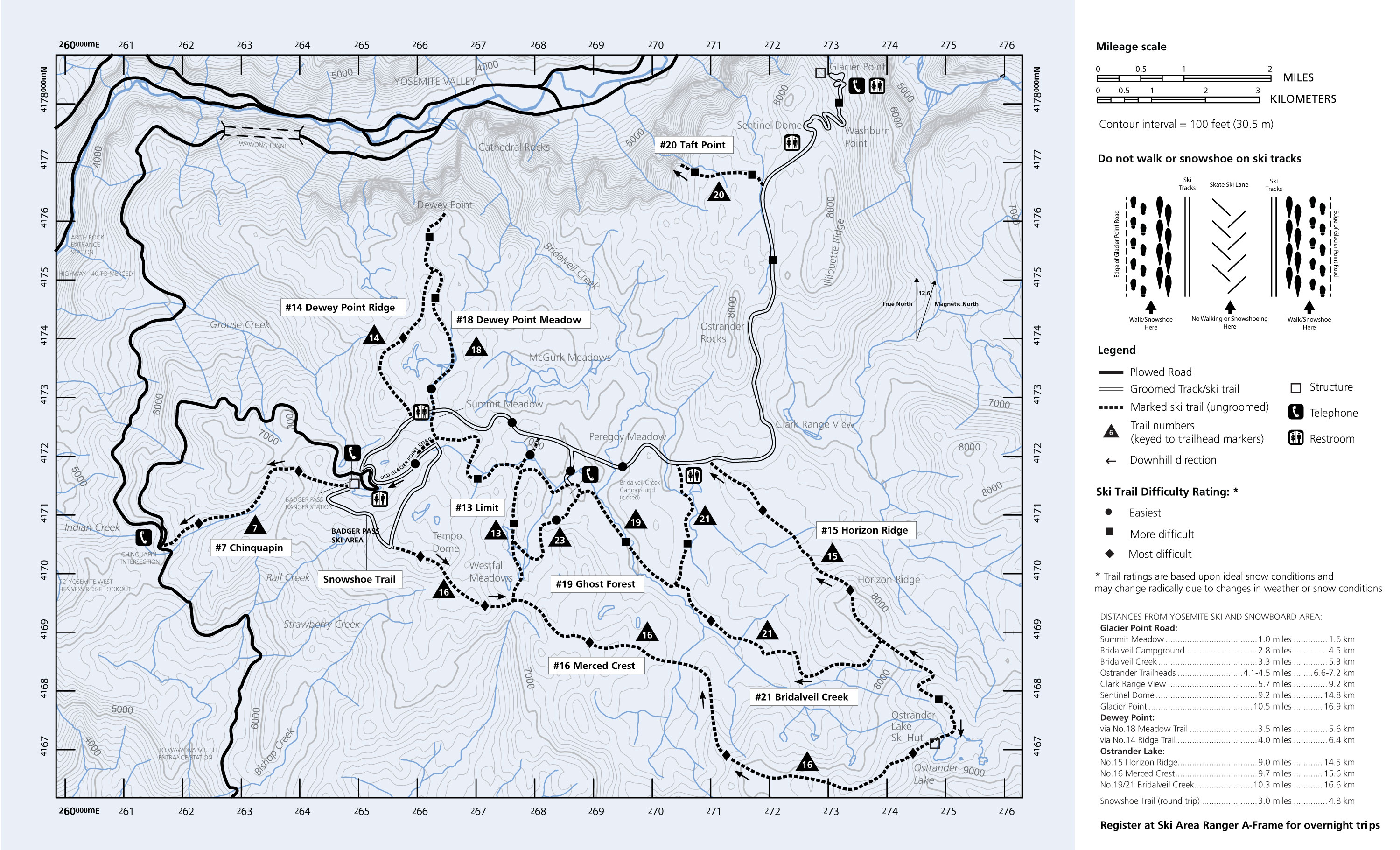
Understanding the Map
The map uses the Universal Transverse Mercator (UTM) coordinate system, which divides the area into a grid measured in meters. While the technical details of the system can be complex, the key takeaway is that the grid allows for precise location identification. The longitudinal (north-south) scale is labeled as Meters Northing (mN), and the latitudinal (east-west) scale is labeled as Meters Easting (mE). The numbers increase northward and eastward from the lower-left corner of the map.
True north is at the top of the map. On the right side, two arrows indicate true north and magnetic north, with magnetic north being 12.6 degrees clockwise from true north at the time the map was drawn. The gray contour lines represent elevation in feet, with 100-foot intervals marking changes in terrain.
Key Features and Roads
Badger Pass Ski Area is slightly left of center on the map, with Yosemite Valley located at the top. The solid black lines indicate roads:
- Wawona Road (State Route 41) runs north-south on the left side of the map. It passes through Wawona Tunnel before entering Yosemite Valley.
- Glacier Point Road branches off Wawona Road and extends eastward, ultimately leading to Glacier Point, a prime viewpoint overlooking Half Dome.
- The Badger Pass Access Road, a short 0.2-mile loop road, leads to the ski lodge and parking lots.
Glacier Point Road is plowed only from Wawona Road to the ski lodge. Beyond this point, it becomes a groomed cross-country ski trail. The map represents this transition by changing the road’s depiction from a thick solid black line to a double thin line. The Historic Snowshoe Trail, which forms a loop around the ski area, is also groomed and connects to Glacier Point Road near its intersection with the access road.
Historic Trails and Landmarks
The map also highlights Old Glacier Point Road, which should not be confused with the modern Glacier Point Road. Built in 1882–1883, the original road passed through Badger Pass and continued 6.46 miles northeast to Glacier Point. While the modern paved road now bypasses the pass, portions of the old route remain as trails. One such segment is part of the Historic Snowshoe Trail.
Two historic ski huts appear on the map as hollow squares. The Ostrander Lake Hut, located at the lower right corner, is labeled, while the Glacier Point Hut, at the upper right corner, is shown but not labeled. These huts provide overnight accommodations for backcountry skiers.
Map Legend
The map’s legend offers useful details, including:
- Symbols indicating the difficulty ratings of the ski trails.
- Locations of amenities such as telephones and toilets.
- Arrows showing the downhill direction for specific trails.
This map is an essential tool for planning a cross-country ski trip at Badger Pass, helping visitors navigate the diverse trail system and make the most of their winter adventure.
Cross-Country Skiing Trailheads at Badger Pass
The Badger Pass area features four main trailheads that provide access to its extensive cross-country skiing network. Each trailhead is conveniently located and clearly marked on the Cross-Country Skiing Trail Map of Badger Pass, helping visitors begin their adventures with ease.
Two of the trailheads are situated near the Badger Pass ski lodge, making them the most accessible starting points for skiers heading out on the groomed and ungroomed trails. These trailheads provide direct access to popular routes, including the Glacier Point Road Trail and the Historic Snowshoe Trail.
The third trailhead lies approximately half a mile from the ski lodge, along the Old Glacier Point Road Trail. This short, ungroomed access trail follows the path of the original dirt road that once led to Glacier Point, offering a quieter alternative for those seeking a less-traveled route.
The fourth trailhead is located at the top of the Eagle ski lift, providing direct access to the Historic Snowshoe Trail and the Merced Crest Trail. This entry point is ideal for skiers who want to begin their journey at a higher elevation on the Snowshoe trail and enjoy a different perspective of the surrounding landscape, and to access the Merced Crest Trailhead.
Skiers should take care to distinguish between the Glacier Point Road Trail—the groomed route leading to Glacier Point—and the Old Glacier Point Road Trail, the shorter, ungroomed access trail near the lodge. Understanding the difference between these similarly named trails helps avoid confusion and ensures a smoother skiing experience.
Trail Markings
Navigating the cross-country skiing trails at Badger Pass is made easier with a system of trail markers and signs placed throughout the network. Each trail is assigned a unique number, and many trails also have names to help skiers identify routes more easily. While the National Park Service provides maps to guide visitors, it’s essential to keep in mind that trail difficulty ratings are based on ideal snow conditions and can vary depending on weather and snow quality.
Metal markers and signs are used to indicate designated trails. These markers are typically fastened to trees, but heavy snowfall or strong winds can obscure or dislodge them, making them harder to spot—particularly on ungroomed trails. Skiers should remain attentive and not rely solely on pre-existing tracks, which may lead off-trail or become confusing in changing conditions.
Before setting out, it’s wise to consult with the Nordic Center or the Ranger Station for the latest trail conditions and updated information on signage. Although most markers follow a standard design, there may be variations in shape and appearance, so checking in with park staff can help avoid confusion.
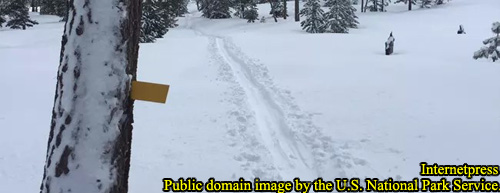
Below is an image of a typical trail marker attached to a tree, serving as an example of what to look for along the trails.
Staying Over-Night at a Ski Hut
Cross-country skiing at Badger Pass offers not just day trips but also the opportunity for multi-day adventures through the use of two historic ski huts: the Glacier Point Ski Hut and the Ostrander Lake Ski Hut. Both huts provide rustic accommodations for those seeking to immerse themselves in Yosemite’s winter backcountry. While visitors can make day visits to either hut, overnight stays require a reservation, payment, and a National Park Service Wilderness Permit. Each hut offers a unique experience, with Glacier Point Ski Hut marking the end of the Glacier Point Road Trail and Ostrander Lake Ski Hut accessible via several routes, the most direct being the Merced Crest Trail.
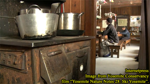
Glacier Point Ski Hut
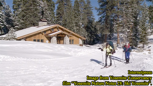
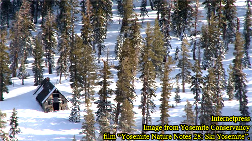
The Glacier Point Ski Hut plays a dual role depending on the season. In the summer months, it operates as the Glacier Point Gift Shop and Snack Stand, serving visitors who arrive via Glacier Point Road. In the winter, however, it transforms into the Glacier Point Ski Hut, providing shelter to cross-country skiers. Located at an elevation of 7,232 feet (2,204 m), the hut sits on the rim of Yosemite Valley, approximately 10.7 miles (17.2 km) from the Badger Pass Ski Area.
During the winter season, Glacier Point Road becomes the Glacier Point Road Cross-Country Skiing Trail, which is groomed by the National Park Service to ease travel for skiers. The hut is only open when the Badger Pass Ski Area is operational. Once there, visitors are rewarded with breathtaking views of Half Dome, Yosemite Valley, and the High Sierra—some of the most iconic sights in the Sierra Nevada. Architecturally, the hut features rustic stone and timber park-style construction, adding to its backcountry charm.
Be aware that children must be at least 14 years old, accompanied by an adult, and pets are not allowed.
Accommodations at Glacier Point Ski Hut
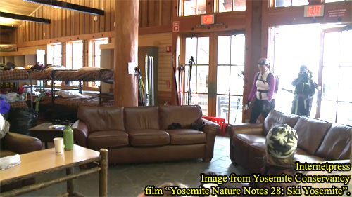
Inside the Glacier Point Ski Hut, guests will find a dining room with prepared meals, sofas for relaxation, a woodstove providing warmth, restrooms, and potable water. A bunk area accommodates up to 20 people in a shared room.
Guests can rent sleeping bags, backpacks, and skiing equipment at the Nordic Center at Badger Pass. The hut host prepares meals and provides packed lunches for day excursions.
Operating Status
The hut is only open while the Badger Pass Ski Area is open. Check the National Park Service website or the Yosemite Hospitality Glacier Point Ski Hut page for current operating information.
For the most accurate information, call Yosemite Hospitality's telephone at 1 (888) 413-8869. Be aware that their website may not always be fully up to date.
Reservations for Glacier Point Ski Hut
The Glacier Point Ski Hut is managed by Yosemite Hospitality, a park concessioner. A hut host is stationed at the hut 24 hours a day during its operating season. While the hut is not located within a designated wilderness area, certain park rules still apply.
Reservation Details:
- Overnight stays require reservations through the Yosemite Hospitality.
- Reservations include lodging, dinner, breakfast, and packed lunch.
- A minimum of six guests is required for a self-guided overnight trip. Solo skiers or smaller groups may be combined to meet the minimum.
- Reservation fees apply. See our separate fee article or visit the Yosemite Hospitality website for up-to-date rates (to be published later this year).
- Reservation can be made through the Badger Pass Nordic Center by dialing 1 (209) 372-8444 or through the Yosemite Hospitality main phone number at 1 (888) 413-8869.
Ostrander Lake Ski Hut
Unlike Glacier Point Ski Hut, the Ostrander Lake Ski Hut is dedicated solely to winter backcountry skiing. Its summer use is uncertain. Located in designated wilderness at an elevation of 8,500 feet (2,590 m) and approximately 7.1 miles (11.4 km) from Badger Pass, the hut overlooks Ostrander Lake, which rests in a glacially carved cirque valley.
And unlike the Glacier Point route, no roads or groomed trails lead to the Ostrander Hut. Multiple trails provide access, with the Merced Crest Trail being the most direct. Wilderness-specific regulations apply, and the hut’s operating schedule is independent of the Badger Pass Ski Area, relying on snow conditions.
The hut is operated and maintained by the Yosemite Conservancy, a non-profit organization. Built in 1941, the hut is a historic two-story stone structure. It is open only during the winter season.
Accommodations at the Ostrander Ski Hut
The Ostrander Hut offers single bunk beds, one bed per person, and a communal kitchen with some cookware. There are two toilets and solar-powered lighting. A woodstove provides heating.
Guests must bring food and a water filter. You are responsible for collecting water from the lake through a hole in the lake ice. Whether or not the hut provides a tool for digging through the ice is unknown.
You are also responsible for a sleeping bag and personal gear.
Access When Badger Pass Ski Area is Closed
If the Badger Pass Ski Area is closed, the gate on Glacier Point Road near Wawona Road is typically locked. In this case, access is only possible via the Chinquapin Trailhead at the Wawona and Glacier Point Roads intersection or possibly via the closed, unplowed, Glacier Point Road. Be aware that theses routes add distance and difficulty to the trek, especially along the Chinquapin trail.
Challenges of Reaching Ostrander Hut
A trip to Ostrander Hut is not recommended for novice skiers. Unlike the relatively flat trail to Glacier Point, Ostrander’s routes are physically demanding and require significant stamina and backcountry experience.
Important considerations
Be prepared to camp overnight en route if necessary. Weather conditions can slow progress and make reaching the hut in one day difficult. Travel to Ostrander Hut requires self-reliance; do not expect a rescue. A National Park Service Wilderness Permit is required.
Reservations for the Ostrander Hut
Overnight stays at Ostrander Hut require reservations, handled by the Yosemite Conservancy.
The cost is approximately $50 per person per night. Contact for reservations is 1 (209) 272-0740, or visit the Yosemite Conservancy’s Ostrander Ski Hut page for more information. (Reservations must still be made by phone.) Their website includes a helpful FAQ section for trip planning.
Trekking Options: Solo, Guided, or Group
When planning an overnight cross-country skiing trek in the Badger Pass area, there is one essential rule to keep in mind: all overnight treks, whether or not they include a stay at a ski hut, require a National Park Service Wilderness Permit. This permit is mandatory, ensuring both the preservation of Yosemite’s backcountry and the safety of visitors. If you plan to stay overnight at either the Glacier Point Ski Hut or the Ostrander Lake Ski Hut, you will also need to secure a reservation. Details about the reservation systems and the huts’ operating schedules were covered in earlier sections of this article.
Solo Cross-Country Skiing Trek
A trek to either hut can be completed by skiing solo, hiring a guide, or traveling with a group. Each option offers a different experience and level of support. If you wish to trek alone and stay overnight at a hut, you must have a reservation at that specific location. For the Glacier Point Ski Hut, you can make reservations through the concessioner by calling the Badger Pass Nordic Center at 1 (209) 372-8444 or 1 (209) 372-4996, or Yosemite Hospitality's main number 1 (888) 413-8869. The Glacier Point Hut requires a minimum group size of six people for reservations, so solo travelers must either form a group or be combined with other parties. By contrast, the Ostrander Lake Ski Hut has no minimum group size, and reservations can be made by contacting the Yosemite Conservancy at 1 (209) 372-0740.
Guided Cross-Country Skiing Trek
For those seeking guidance, you have the option to hire a guide. Yosemite Hospitality, the park concessioner, offers guide services through the Nordic Center at Badger Pass. These services are available only when the ski area is open. Yosemite Hospitality works in partnership with the Yosemite Mountaineering School to provide guided trips to both the Glacier Point and Ostrander Lake huts, as well as other destinations within Yosemite’s backcountry. To learn more or make reservations for guided treks, you can contact the Nordic Center at 1 (209) 372-4996, or reach the Yosemite Mountaineering School at 1 (209) 372-8344, or email them at yms@aramark.com. Independent guides may also be available, though no specific recommendations are provided here. Whether you choose a concessioner or an independent guide, both can lead you to the huts or other routes throughout the park.
Group Cross-Country Skiing Trek
If you prefer to trek as part of a group without hiring a guide, you have several options. For the Glacier Point Ski Hut, you’ll need to meet the minimum group size requirement of six people to secure a reservation. If your group has fewer than six participants, Yosemite Hospitality will attempt to combine your party with other skiers to meet the requirement, although this does not mean you need to travel together. Reservations for Glacier Point Hut group treks can be made by calling 1 (209) 372-8444.
Traveling to the Ostrander Lake Ski Hut as part of a group offers greater flexibility. You can form your own group without any minimum size requirement. To reserve space for your group, simply contact the Yosemite Conservancy at 1 (209) 372-0740. Alternatively, if you want to join an existing group, the Yosemite Winter Club (YWC) provides a great option. The club’s Cross Country Section (YWCXC) regularly organizes group treks to various backcountry locations, including the Ostrander Lake Ski Hut. The YWC, a non-profit organization founded in 1928, promotes winter sports activities in Yosemite. To participate in one of their group treks, you must join the club for a $25 membership fee and likely pay an additional reservation fee for the specific trip. For information about joining the club or signing up for their scheduled treks, you can call 1 (916) 454-5937 or visit their website at yosemitewinterclub.com
No matter which trekking option you choose, planning ahead is essential. Ensure you secure the required permits and reservations, check weather conditions, and prepare for the physical demands of a winter trek in Yosemite’s backcountry. Taking these steps will help you enjoy a safe and memorable skiing adventure.
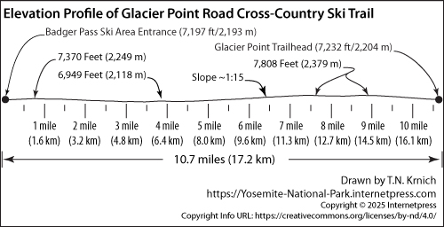
Glacier Road Cross-Country Ski Trail Profile
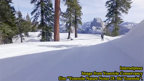
The Glacier Point Road Cross-Country Ski Trail is a scenic and popular route that begins at the Badger Pass Ski Area entrance and extends to Glacier Point. This 10.7-mile (17.2 km) trail follows the course of Glacier Point Road, which is transformed during the winter into a groomed ski trail when the Badger Pass Ski Area is open. The grooming process, conducted with snow machines, helps create a smoother and more enjoyable skiing experience.
The trail’s slopes are generally gentle, making it accessible to a wide range of skiing abilities. The gradient rarely exceeds a 1:15 slope ratio, meaning the elevation rises no more than one foot for every fifteen feet of distance. Throughout the trail, elevation fluctuates by about 421 feet (131 m). The highest point, located near the start at Badger Pass, reaches an elevation of 7,370 feet (2,249 m), while the lowest point, situated approximately 2.5 miles (4 km) from the start, descends to 6,949 feet (2,118 m).
Upon reaching the end of the trail at Glacier Point, skiers will find the Glacier Point Trailhead, located just beyond the Glacier Point Ski Hut. This final stretch provides access to the rim of Yosemite Valley, where breathtaking panoramic views await. Among the highlights is a stunning vantage point of Half Dome, one of Yosemite’s most iconic landmarks.
Whether you’re seeking a moderate day trip or part of a longer overnight excursion to the Glacier Point Ski Hut, the Glacier Point Road Cross-Country Ski Trail offers a rewarding journey through Yosemite’s serene and snow-covered landscapes.
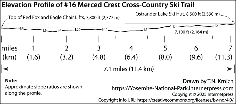
Merced Crest Cross-Country Ski Trail Profile
The Merced Crest Cross-Country Ski Trail is a challenging and remote route designed for experienced and well-prepared backcountry skiers. This ungroomed trail is never maintained with snow machines, requiring skiers to navigate natural snow conditions, which can be variable and demanding. Strength, endurance, proper equipment, and backcountry navigation skills are essential for anyone attempting this trek. Serious preparation is critical, as the trail presents both physical and technical challenges.
The trail begins at the top of the Red Fox and Eagle Chair Lifts within the Badger Pass Ski Area and ends at the Ostrander Ski Hut, a rustic backcountry shelter located deep within Yosemite’s wilderness. Spanning a length of 7.1 miles (11.4 km), the route follows mountain ridges and crosses three small valleys, providing a mix of steep climbs and descents. Importantly, the trail remains open regardless of whether the Badger Pass Ski Area is operating, allowing access even when the lifts and facilities are closed.
Elevation changes along the trail are significant, with fluctuations of approximately 1,400 feet (426 m). The trailhead elevation starts at 7,800 feet (2,377 m). Skiers will encounter two low points, both at around 7,100 feet (2,164 m), as the trail dips into the valleys. The highest point is reached at the Ostrander Ski Hut, standing at an elevation of 8,500 feet (2,590 m).
The slopes along the Merced Crest Trail are steep and demanding, with gradients ranging from 1:5 to 1:20. Much of the terrain exceeds a 1:10 slope ratio, making the climbs and descents challenging, especially when carrying overnight gear. There are at least two sections where the incline reaches a steep 1:5 ratio, requiring careful technique and significant physical effort to ascend or descend safely.
Despite the demanding conditions, the trail offers a rewarding backcountry skiing experience, taking adventurers through pristine alpine landscapes and leading to the remote comfort of the Ostrander Ski Hut. Skiers undertaking this route should ensure they are fully prepared for the rigors of winter wilderness travel, as the journey is suited only for those with advanced skiing abilities and proper planning.
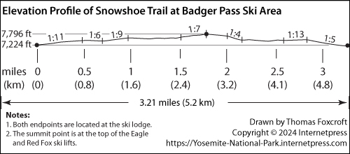
Snowshoe Trail Profile at Badger Pass Ski Area
The Snowshoe Trail at Badger Pass Ski Area is a groomed trail that offers a versatile experience for both snowshoers and cross-country skiers. Following the perimeter of the ski area, the trail provides a scenic route through the surrounding forest and meadows, making it an inviting option for visitors seeking a moderate outdoor adventure. At 3.2 miles (5.2 km) in length, the trail forms a loop with both endpoints located in Monroe Meadow, conveniently situated adjacent to the Badger Pass ski lodge.
Starting in Monroe Meadow at the trail’s lowest elevation of 7,224 feet (2,202 m), users gradually ascend along gentle slopes. The highest point, reaching 7,796 feet (2,376 m), lies about halfway around the loop. This high point can be easily accessed via the Eagle or Red Fox ski lifts, providing an alternate starting location for those looking to shorten the trek or begin at a higher elevation.
Throughout the trail, the slopes vary between a 1:13 and 1:4 gradients. The gentler sections, with a 1 foot rise for every 13 feet of distance (1:13), offer a comfortable climb for beginners. The steeper stretches, though more challenging, serve as excellent practice for those aiming to tackle more demanding routes in the area. The Snowshoe Trail is particularly suitable for visitors new to cross-country skiing or snowshoeing who want to gain experience with moderate elevation changes in a controlled environment.
An enjoyable feature of completing the loop is that the trail ends back at Monroe Meadow, allowing for a convenient finish near the Badger Pass ski lodge. After a refreshing trek, many visitors choose to unwind with a warm meal at the lodge, rounding out their day in the Sierra Nevada with both adventure and relaxation.
Below is an image of the trail profile, showing the elevations of the two endpoints and the gradual rise and descent along the route.