Hiking Trail to El Capitan
Discover the awe-inspiring El Capitan Trail in Yosemite National Park. Learn about its history, hiking routes, and tips for an unforgettable adventure.
Publish Date: March 20, 2025
Revision Date: March 20, 2025
Yosemite National Park Visitor's Guide is a Trademark.
Copyright © 2025 by Internetpress®
Introduction
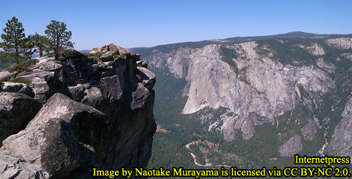
El Capitan stands as one of Yosemite National Park’s most recognizable landmarks, a colossal rock promontory that commands attention with its sheer size and presence. Projecting outward into Yosemite Valley like a peninsula extending into a body of water, El Capitan is a natural wonder sculpted from granite, displaying both rugged strength and serene beauty. Its base stretches approximately 3,300 feet (1,006 m) wide, gradually tapering to about 825 feet (251 m) at the summit—just 25% of the width of its base. Rising from the valley floor, which sits at 4,000 feet (1,219 m) above sea level, El Capitan’s summit reaches 7,570 feet (2,307 m), giving it a towering height of about 3,570 feet (1,088 m). This dramatic elevation and the distinct slope that creates the formation’s prominent “nose” are testaments to the geological forces that shaped Yosemite Valley.
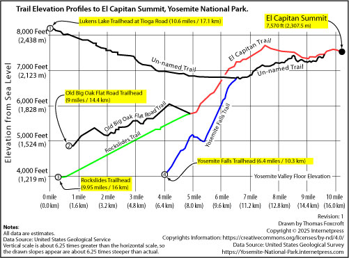
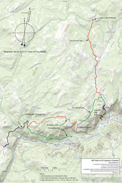
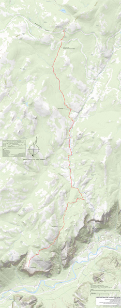
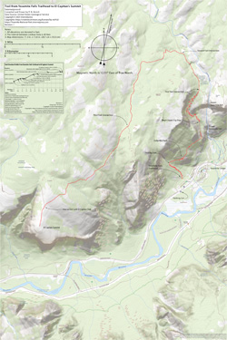
For those who wish to experience El Capitan’s grandeur from its summit, rather than by climbing its sheer face, there are four designated park paths that wind their way to the top. Each path offers a unique approach, beginning at its own trailhead: the Lukens Lake Trailhead, the Old Big Oak Flat Western Trailhead, the Rockslides Trailhead, and the Upper Yosemite Falls Trailhead. While each path is distinct in its terrain and difficulty, they all converge onto a common route known as El Capitan Trail, which leads the final stretch to the summit. The distance of a one-way hike to the summit ranges from 6.4 miles (10.3 km) to 10.6 miles (17 km), with the time required for this journey spanning from 4.25 hours to 6.5 hours, depending on the chosen path and pace.
The Lukens Lake Trailhead offers the least strenuous path, making it an appealing choice for those seeking a less demanding journey, even though it is the longest in distance. In contrast, the trail from the Upper Yosemite Falls Trailhead, though the shortest, is the most challenging due to its steep and demanding ascent. Regardless of the path chosen, hikers are advised to plan for an overnight camp at or near the summit to fully appreciate the experience without the rush of a single-day hike. However, an overnight stay requires a free wilderness permit, which can be obtained from the park’s designated stations.
In the sections that follow, we will explore each path to the summit in greater detail, offering guidance to help you choose the route that best suits your preferences and abilities. Whether you seek a leisurely hike with sweeping vistas or a more intense climb that tests your endurance, El Capitan’s trails promise an unforgettable adventure amidst the breathtaking landscapes of Yosemite.
Vegetative Zones which the Trails Pass Through
As hikers ascend the trails leading to El Capitan’s summit, they journey through a diverse range of vegetative zones, each with its own unique blend of flora and climate. From the warmer, sun-dappled forests of the lower elevations to the cool, wind-swept heights near the summit, these zones offer an evolving tapestry of sights, scents, and sounds that enrich the hiking experience. The trails pass through three distinct vegetative zones between elevations of 4,000 and 8,200 feet (1,219 to 2,500 m), each providing a glimpse into the remarkable biodiversity of Yosemite National Park.
The first of these zones is the Lower Montane Forest, spanning elevations from about 3,000 to 6,000 feet (900 to 1,829 m). This zone is defined by its Mediterranean climate, with hot, dry summers and cool, moist winters. Snowfall is common during winter, often covering the ground for several months. The diversity of tree species in this zone makes it an enchanting forest to explore. Towering Ponderosa pines, incense-cedar, and white fir form much of the canopy, while the broad leaves of California black oak add variety and warmth in the fall. While Yosemite’s giant sequoia groves, such as the Mariposa, Merced, and Tuolumne Groves, thrive within this zone, the trails to El Capitan do not pass directly through these ancient stands. Nonetheless, the Lower Montane Forest offers a rich array of sights, from sunlit clearings to shaded groves where moss clings to rocks and fallen branches.
Continuing upward, hikers enter the Upper Montane Forest at elevations ranging from about 6,000 to 8,000 feet (1,829 to 2,439 m). Here, the climate shifts to short, moist, cool summers and long, cold winters. Snowfall begins in November, often piling up to six feet and lingering until June. This zone is characterized by pure stands of red fir and lodgepole pine, their straight trunks and dark green needles forming a stately procession along the trails. The Jeffrey pine, with its bark that emits a faint scent of vanilla when warmed by the sun, is another notable inhabitant of this forest. Picturesque western junipers, with their twisted trunks and deep-red bark, add a sense of age and endurance to the landscape. In the meadows that punctuate these forests, vibrant wildflowers burst into bloom from June through August, transforming clearings into vivid patches of color that attract a variety of butterflies and other pollinators.
As the trail climbs higher, it reaches the Subalpine Forest zone, which begins near 8,000 feet (2,439 m). The air becomes crisper, and the growing season shorter, with long, snowy winters that blanket the ground in three to nine feet of snow. The trees here are adapted to these harsh conditions. Western white pines, with their soft needles, and mountain hemlocks, whose branches droop under the weight of snow, thrive alongside lodgepole pines, which continue their ascent from the Upper Montane zone. Subalpine meadows, open and windswept, come to life from July through August with a profusion of wildflowers, their bright hues a striking contrast against the granite outcrops and lingering snow patches.
The transition through these vegetative zones not only highlights the diversity of Yosemite's flora but also marks the progress of the hike, offering a constantly changing backdrop of forest scents, colors, and textures. Each step upward unveils a new layer of beauty, making the journey to El Capitan’s summit as rewarding as the destination itself.
Hiking from Lukens Lake Trailhead
Starting at the Lukens Lake Trailhead along Tioga Road, the path to the summit of El Capitan offers a less strenuous way to reach this iconic granite monolith. Located about 16.5 miles (26.4 km) east of the intersection with Big Oak Flat Road, the trailhead is equipped with a parking lot and metal cabinets for storing food, ensuring that your vehicle remains safe from the park’s curious bears. From here, hikers set off on a 10.6-mile (17.1 km) journey to the summit, traversing a landscape that balances adventure with accessibility. You should plan for at least a four hour and fifteen minute hike to the summit.
The trail begins at an elevation of approximately 8,179 feet (2,493 m), gradually descending to its lowest point of about 6,827 feet (2,081 m) before climbing again to the summit at 7,570 feet (2,307 m). The path’s relatively gentle slopes and mostly flat terrain make it an appealing choice for those seeking a less demanding hike without sacrificing the grandeur of Yosemite's backcountry. Along the way, the trail meanders through a mix of sun-dappled forests and open stretches that provide glimpses of distant peaks and valleys.
Navigating the route is straightforward, thanks to signs posted at intersections with other trails. While most of these trails are un-named, they are well-trodden and blend seamlessly with the main path. This network of trails adds to the sense of exploration while providing multiple ways to approach the journey. Within about 1,300 feet (411 m) of the summit, the un-named trail connects with the El Capitan Trail, guiding hikers toward the final ascent.
Reaching the summit is a reward in itself. The expansive views from the top span across Yosemite Valley, with the Merced River winding far below and familiar landmarks rising in the distance. For those who have taken this route, the combination of its gentler incline and the sheer splendor of the surroundings makes the hike from Lukens Lake Trailhead a memorable path to the top of El Capitan.
Hiking from the Yosemite Falls Trailhead
Starting your journey at the Yosemite Falls Trailhead, situated conveniently next to Northside Drive in Yosemite Valley, you’re already in one of the most iconic spots in the park. It’s easy to find, marked by a significantly large parking lot that caters to the steady flow of visitors eager to glimpse the majestic Yosemite Falls. This trailhead, not to be confused with the Lower Yosemite Falls Trailhead a short 0.4 miles (0.7 km) east, is your gateway to the summit of El Capitan. Though it offers the shortest route to the top, the path is known for its steep ascent, challenging hikers right from the start.
From the trailhead, the summit lies 6.4 miles (10.3 km) ahead. You should plan for at least a six hour and twenty-five minute hike to the summit. The initial stretch demands determination as you navigate a series of switchbacks that climb relentlessly up the valley wall. Over the first 2.5 miles (4 km), the trail ascends at an average slope of 3,473 feet per mile (803 m/km), making this one of the more strenuous segments of the journey. Fortunately, the challenge is punctuated by a reprieve about halfway up, where the trail flattens for roughly ¾ mile (1.2 km). This level stretch isn’t just a welcome break for your legs—it also offers breathtaking views of Yosemite Falls cascading down its full 2,425 feet (739 m), as well as sweeping vistas across the valley, including a glimpse of the iconic Half Dome in the distance.
After conquering the switchbacks and pausing to soak in the scenery, you’ll press onward to the valley rim. From here, the trail levels out again, offering a gentler path that leads to the junction with the El Capitan Trail. The final ¼ mile (402 m) is a gratifying stretch that guides you to the summit itself. As you approach the top, the air is crisper and the views even more commanding, making the effort of the ascent feel all the more worthwhile.
Reaching the summit of El Capitan, you’re rewarded with unparalleled panoramas that capture the essence of Yosemite’s grandeur. The vastness of the park unfolds before you, a mosaic of granite peaks, verdant forests, and the winding Merced River far below. The journey from the Yosemite Falls Trailhead to this point is a demanding yet unforgettable experience, offering some of the most spectacular sights in Yosemite for those who are willing to make the climb.
A Short History of Old Big Oak Flat Road
The history of the Old Big Oak Flat Road is a tale of ambition, danger, and the evolving needs of Yosemite’s visitors. Built as a toll road in the late 1800s, it was part of a fierce competition to establish the first wagon route into Yosemite Valley. Though it was ultimately the second to succeed, the Big Oak Flat Road became a vital artery, channeling the majority of park traffic from central and northern California. With a width averaging 13 feet and a maximum grade of 16 percent, the old road challenged both horses and early automobiles as they climbed and descended the rugged Sierra slopes.
The most notorious stretch of the road snaked along the steep north wall of the valley entrance, an area now known as the rock slides. This segment featured a sharp switchback infamously called the "Zig-zag," where the road’s narrowness and precipitous drops created a gauntlet for drivers. Despite efforts to ensure safety, accidents were not uncommon. Tragedy struck in the early 1930s when a Packard went over the edge, claiming a passenger’s life. In July 1937, a similar fate befell a Lincoln, resulting in the death of a woman passenger. The risks of the "Zig-zag" even prompted the Secret Service to bar President Franklin Roosevelt from using the road, fearing that his long presidential touring car could not turn around safely if an emergency arose.
The completion of the New Big Oak Flat Road in 1940 spelled the end for its predecessor. Modern engineering created a safer and more reliable route between Crane Flat and Yosemite Valley, diverting the bulk of traffic away from the perilous old path. Nature soon moved in to reclaim the abandoned route. In May 1945, a massive rockslide swept away the "Zig-zag" switchback, forcing the road’s permanent closure. Over the years, additional rockslides have buried sections of the route between Rainbow View and the Valley floor, transforming it into a hiking trail for today’s visitors.
For those who walk the old path, small remnants of asphalt serve as quiet reminders of the daring early travelers who once ventured this way, carving a passage through Yosemite’s untamed wilderness.
Hiking from Old Big Oak Flat Road Trailhead
The hike from the Old Big Oak Flat Road Trailhead to the summit of El Capitan offers a journey through Yosemite’s rugged backcountry, blending steep climbs with stretches of relative ease. The trailhead itself is somewhat inconspicuous, located just off [New] Big Oak Flat Road at an elevation of 4,840 feet (1,475 m). An unmarked parking lot, equipped with metal cabinets for storing food securely from bears, sits about a mile (1.6 km) west of the tunnel on Big Oak Flat Road and roughly 1,300 feet (396 m) west of the intersection with Yosemite National Park Road. For those who find it, this parking area provides a quiet starting point for the nearly 9-mile (14.4 km) trek to the summit. You should plan for at least a six hour hike to the summit.
The path initially winds through sun-drenched chaparral, where hardy shrubs and dry, fragrant vegetation dominate the landscape, before gradually entering a dense forest area. As the trail ascends at a moderate incline, averaging a slope of about 250 feet per mile (47.6 m/km), the canopy closes in, offering shade and glimpses of granite cliffs that hint at the grandeur ahead. About 7.8 miles (12.6 km) in, the Tamarac Trail intersects with the Old Big Oak Flat Road Trail, near where Coyote and Cascade Creeks converge. This point serves as a waypoint, signaling that the most challenging section of the ascent lies just ahead.
Not far beyond this junction, at around the 4.41-mile (7.1 km) mark, the trail splits into two distinct routes. The Rockslides Trail branches off downhill to the southeast, following the old wagon road along the valley wall to the base of El Capitan. Meanwhile, the El Capitan Trail turns north and sharply uphill, leading directly to the summit. This section of the trail is the most demanding, with a slope of about 955 feet per mile (182 m/km) over the next 1.25 miles (2 km). The ascent tests both endurance and resolve, but for those who persist, the effort is rewarded.
Beyond this steep climb, the path levels out considerably, and the remaining 3 miles (4.8 km) to the summit traverse relatively flat terrain. Here, the forest canopy opens up at intervals, revealing glimpses of Yosemite Valley and the vast granite expanse of El Capitan itself. The transition from strenuous switchbacks to gentler inclines provides a welcome reprieve for tired legs, making the final approach to the summit both exhilarating and manageable.
The journey from the Old Big Oak Flat Road Trailhead to the top of El Capitan is more than a hike; it’s a passage through Yosemite’s natural history, marked by shifting landscapes, historic pathways, and the enduring allure of one of the park’s most iconic landmarks. For those who reach the summit, the reward is not just the view but the memory of the trail itself—every switchback, every stretch of granite, and every echo of those who traveled the path before.
Hiking from Rockslides Trailhead
Setting out from the Rockslides Trailhead, hikers embark on a path that weaves through both history and natural beauty. Located in the valley at the base of El Capitan, the trailhead is accessed by a short walk from a nearby parking lot. This unmarked lot lies about half a mile (0.8 km) west of the intersection of Northside Drive and El Capitan Drive, alongside the often dry Ribbon Creek. After parking, hikers proceed along a 460-foot (140 m) trail that leads to the Valley Loop Trail. A left turn followed by a 1,543-foot (470 m) walk westward brings adventurers to the beginning of the Rockslides Trail.
This trail, following the Old Big Oak Flat Road, quickly reveals the rugged character for which it is known. Rockslides are a real hazard here, and it’s wise to stay alert for both visible and audible signs of falling rocks. One of the most notorious sections is the Zig-zag, a series of sharp switchbacks that demand both caution and stamina. Beyond this point, the trail offers a mix of challenges and rewards as it climbs toward El Capitan’s summit.
Hikers should prepare for a long trek, as the route stretches approximately 9.9 miles (16 km) to the summit, with an elevation gain that tests even experienced hikers. The first 4.5 miles (7.25 km) lead to the intersection with El Capitan’s Western Trailhead, ascending steadily at an average slope of 444 feet per mile (84.5 meters per kilometer). Once on the El Capitan Trail, the incline becomes more intense, rising to about 955 feet per mile (182 meters per kilometer) for the first 1.25 miles (2 km). After this demanding section, the path flattens out, making the final 3 miles (4.8 km) to the summit a bit less strenuous.
As the trail climbs above the treeline and hugs the valley wall, hikers are rewarded with exceptional views. The expansive vistas offer a breathtaking perspective on Yosemite Valley’s sheer cliffs and deep forests, a spectacle that makes the effort worthwhile. Reaching the summit, the sense of accomplishment is amplified by the panoramic views that stretch for miles. For those seeking a journey filled with both challenge and remarkable scenery, the hike from Rockslides Trailhead to El Capitan’s peak is an unforgettable adventure.
Camping Near El Capitan’s Summit
Camping near the summit of El Capitan is an experience that offers a profound connection to Yosemite’s rugged wilderness. The quiet isolation, paired with breathtaking views, makes it an unforgettable adventure for those willing to make the trek. However, it requires careful planning and adherence to Yosemite's regulations to protect the park's pristine environment.
To begin, securing a Wilderness Permit is mandatory for all overnight stays in Yosemite’s backcountry, including El Capitan. This permit not only helps manage the number of visitors but also ensures that the delicate ecosystems remain undisturbed. When planning your overnight hike, selecting a suitable campsite is crucial for both your safety and the preservation of the wilderness. Yosemite National Park requires that all campsites be located at least 100 feet (about 30 meters) from any water source, such as creeks, streams, or springs. While there are no significant water sources directly at the summit, this regulation is essential to remember when encountering streams during your hike. Keeping this distance protects water quality and preserves the natural habitats of the area.
In addition to water sources, your campsite must be at least 100 feet (about 30 meters) away from any established trails. This guideline ensures privacy for all visitors and helps maintain clear, unobstructed paths. Although formal trails are scarce near El Capitan’s summit, it is still important to camp well off any visible paths used by other hikers. The rocky and uneven terrain offers several potential spots for setting up camp, but it’s vital to be mindful of your surroundings.
Whenever possible, opt for established campsites that show signs of previous use. These sites, often identifiable by flat, barren areas with little to no vegetation, help concentrate human impact and prevent the spread of damage to untouched areas. If an established site is unavailable, look for durable surfaces such as rock, gravel, or dry ground. Camping on these surfaces minimizes soil erosion and prevents lasting harm to Yosemite’s fragile ecosystems. It’s also important to avoid setting up camp in sensitive areas like meadows or spots with delicate vegetation, as these environments are particularly vulnerable to disturbance.
Group size is another crucial factor to consider. Wilderness permits often include restrictions on group size to limit environmental impact. Make sure your campsite can comfortably accommodate your group without spreading out too much, which can lead to greater damage. Large groups, in particular, should exercise extra caution when selecting a spot to avoid concentrating their impact in one area.
Equally important is following the Leave No Trace principles. This means packing out all trash, refraining from disturbing natural features, and ensuring that your campsite is left in better condition than you found it. Human waste should be disposed of responsibly, at least 200 feet (about 60 meters) away from water sources and trails. This commitment to minimizing human impact not only preserves the wilderness for future visitors but also maintains the natural beauty of El Capitan’s summit.