Hiking Trail to Yosemite Falls
Hike Yosemite's most iconic trail to the top of Yosemite Falls—discover dramatic views, trail details, and tips for an unforgettable day or overnight adventure.
by Thomas Foxcroft
Publish Date: May 12, 2025
Revision Date: May 12, 2025
Yosemite National Park Visitor's Guide is a Trademark.
Copyright © 2025 by Internetpress®
Introduction
Yosemite Falls is a breathtaking marvel, composed of an upper fall, a lower fall, and a cascading stretch in between. Of the three main ways to reach this iconic waterfall—one along the valley floor to the Lower Fall, one from the valley floor up the valley wall to the rim, and one from beyond the valley—this article focuses on the steep uphill route that climbs to the top. Whether you choose to make it an up-and-back day hike or spend the night near the rim, this path rewards you with steadily unfolding vistas: the lower stretches of the trail offer only a handful of glimpses of Yosemite Valley and the falls, while the upper half presents increasingly dramatic sights. Finally, at the very top, you’re treated to the most commanding views of all. Standing next to the lip of the Upper Fall—especially when the creek flow is at its peak—is a moment that hikers cherish for a lifetime.
Essential Facts about the Yosemite Falls Trail
Do not get this trail confused with the Lower Yosemite Fall Trail that takes you to the base of the falls. This trail, named the Yosemite Falls Trail, takes you to the top of the falls.
Embarking on the Yosemite Falls Trail offers an up-close encounter with one of North America's tallest waterfalls. Before setting off, understanding key details like distance, difficulty, and best seasons ensures a safer, more rewarding experience.
- Trailhead Name: Yosemite Falls Trailhead
- Trail Terminal Point Observation Area at the brink of the falls.
- Length 3.27 miles (5.27 km)
- Gains in Elevation 3,056 ft (932 m)
- Losses in Elevation 518 ft (158 m)
- Minimum Elevation 4,008 ft (1,222 m)
- Maximum Elevation 6,704 ft (2,044 m)
- Average Elevation 5,379 ft (1,640 m)
- Maximum Slope 34.2º up, 31.4º down
- Average Slope: 11.3º up, 8.0º down
- Approximate one-way hiking time At least 3½ hours
- Difficulty Strenuous
- Best Seasons Late Spring and early summer, since that is when the creek is flowing.
- Nearest Facilities Yosemite Lodge and Yosemite Village
- Permits None required for day hike. Required for overnight hikes. Available in advance or from the Wilderness Center in Yosemite Village.
- Water There is potable water available near the trailhead, at the Camp 4 Restroom, about 1,100 feet (340 m) east of the trailhead. Drinking water is not available along the trail, except for Yosemite Creek, beyond the rim of the valley. Plan ahead and bring plenty of water for your hike. Water from the creek should be properly disinfected before use.
- Restroom and Toilet There is a toilet available near the trailhead, at Camp 4, about 1,100 feet (340 m) east of the trailhead.
Trail profile
If you're eager to understand the distance, steepness, and key waypoints along the Yosemite Falls Trail, the elevation profile, in the image shown below, is an invaluable resource. This Cartesian-style graph uses miles and kilometers on the horizontal axis and feet and meters on the vertical axis—both set to equal scales, so you see a true representation of how the trail rises and falls over its 3.27-mile (5.27-kilometer) course. Along the way, you’ll encounter seven important points that highlight the trail’s varied terrain, which can feature segments with slopes as steep as 34.2º on the climb and 31.4º on the descent, though the overall uphill grade is closer to 11.3º and the overall downhill grade nearer to 8º.
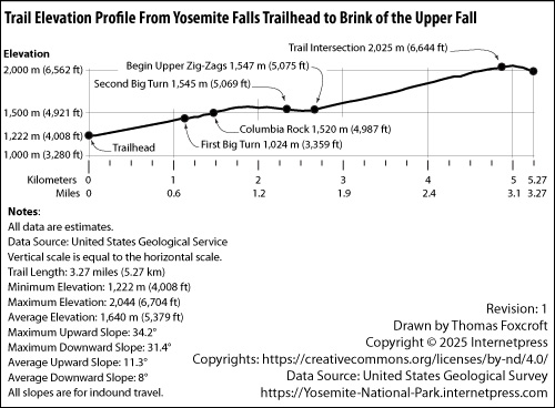
Beginning at the trailhead, roughly the same elevation as Yosemite Valley's 4,008 feet (1,222 meters), the path quickly becomes an 11º ascent to the First Big Turn—a 0.7-mile (1.1-kilometer) stretch that gains 666 feet (203 meters). The incline continues at about 11º for another 0.3 mile (0.55 kilometer) toward Columbia Rock, rising an additional 313 feet (95 meters). After Columbia Rock, the trail maintains its climb at 11º for about 300 feet (100 meters), levels off for approximately 650 feet (200 meters), and then dips at about 8º for the final 246 feet (75 meters) leading to the Second Big Turn. In total, that segment is about 0.4 mile (0.7 kilometer).
From the Second Big Turn to the base of the Upper Zig-Zags—around 0.2 mile (0.4 kilometer)—the path alternates gentle declines and inclines of roughly 8º, with minimal net elevation change. The longest stretch follows: a 1.3-mile (2.1-kilometer) climb from the bottom of the Upper Zig-Zags to the Intersection with No-Name Trail. This section averages a 13.2º grade, and many segments hit the maximum 34.2º slope, culminating in a 1,569-foot (478-meter) elevation gain as the trail nears the valley rim. Finally, from the Intersection with No-Name Trail to the Yosemite Falls Observation Deck, a distance of about 1,600 feet (480 meters), the route descends first at about 11º, then at around 22º, bringing you to the dramatic vantage point above one of the tallest waterfalls in North America.
By studying this profile, you'll know how to pace yourself for the steeper pitches and appreciate the occasional level ground or downhill stretch. This insight helps you anticipate what gear and rest stops you might need, ensuring that your time on the Yosemite Falls Trail is not only achievable but also richly rewarding.
Motion Picture about Yosemite Falls
For those who want to experience Yosemite Falls before setting foot on the trail, a beautifully produced motion picture offers an immersive preview. Created by the Yosemite Conservancy—a nonprofit organization devoted to preserving and enhancing Yosemite National Park—the film was released on December 12, 2009. Running just 9 minutes and 32 seconds, it captures breathtaking images of the falls in their full power and glory.
This short film not only showcases the dramatic beauty of Yosemite Falls, but also provides an informative narrative about its structure and seasonal behavior. With a focus on the times of year when Yosemite Creek is at peak flow, the motion picture helps viewers understand the timing and forces that shape one of North America's tallest waterfalls. It's an excellent introduction for first-time visitors and a stirring reminder for those who have already witnessed the falls in person.
For a link to the live view of the falls, see the references section at the end of this article.
Experiences along the Yosemite Falls Trail
The Yosemite Falls Trail offers hikers a rich and varied journey through both forested canyon and open granite ledge. From the moment you begin your hike near Camp 4, the experience is immersive—steeped in rugged natural beauty and steep physical effort. The trail starts at the base of the valley wall, among massive boulders that tumbled from above long ago. Just steps from the trailhead, you'll find two trail signs: one, a metal panel introducing Yosemite Falls, and another wooden sign marking the trail and distances to notable destinations such as Yosemite Point, Eagle Peak, and North Dome.
The first part of the trail climbs quickly into a dense forest shaded by canyon live oak, ponderosa pine, and incense cedar. Despite the forest cover, the terrain is rocky and demanding. This trail was built for hikers, and although rough, it features impressive stonework that includes hand-laid staircases and narrow, sculpted pathways. Even so, the risk of rockslides is ever-present—sections of the trail cut through steep and unstable cliffs. Hikers have been killed by falling rock in this area, so caution and awareness are essential.
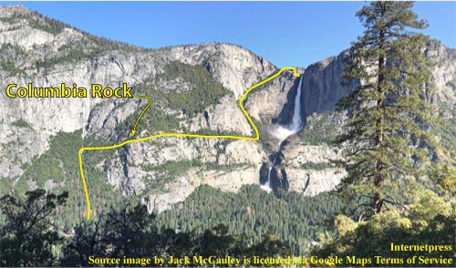
Much of the lower trail is enclosed by forest, offering little in the way of long views. But perseverance pays off. At about one mile (1.6 km) in, you'll reach Columbia Rock, also known as Columbia Point. This is your first real chance to take in the valley below. From here, the panorama is stunning—granite walls, the Merced River, and distant landmarks unfold beneath you. For many hikers, Columbia Point is a worthwhile turnaround spot if time or endurance is limited.
“The view from Columbia Point is stunning, so if you are too tired to hike all the way to the valley's rim, Columbia Point will still leave you fully satisfied.”
If you press on, the trail becomes more exposed as you rise above the tree line. The next exceptional viewpoint comes at the Second Big Turn, roughly 1.4 miles (2.3 km) from the start. Here, you stand near the base of the Upper Fall itself. Depending on the season, you may witness Yosemite Creek in full flow, dropping in a single thunderous plunge down the cliff face. It is a dramatic and awe-inspiring moment, one that connects you with the immense power of water and stone.
Continuing upward, the final destination is the observation deck perched above the Upper Fall. From here, you peer over the lip of one of North America's tallest waterfalls. During peak flow in late spring, the roar is deafening and the mist intense. The deck is safely built into the granite, offering a secure place to appreciate the fall's full height and the dizzying drop below.
While the observation deck marks the end of the Yosemite Falls Trail, hikers with the stamina to continue may want to extend their journey to Yosemite Point. Located about another mile (1.6 km) beyond the falls, it offers a broader, more expansive view of Yosemite Valley—especially rewarding in the early morning light.
This trail is not for the unprepared. It is steep, strenuous, and in some places treacherous. Leaving the trail requires mountain climbing skill and should not be attempted casually. But for those willing to take it on, the Yosemite Falls Trail offers one of the most unforgettable hiking experiences in the park. With every step, you ascend into a landscape carved by ice and water, shaped by time, and preserved for those willing to make the climb.
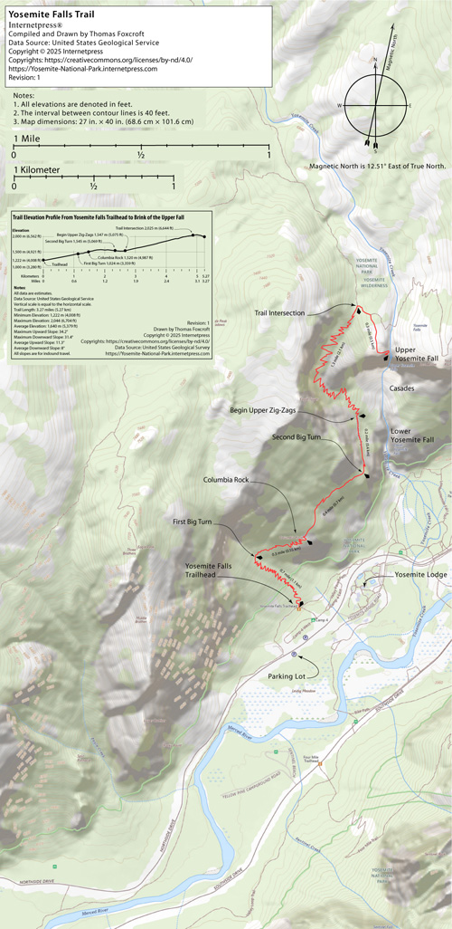
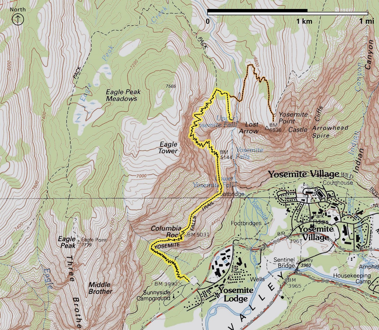
Trail Maps
Reliable maps turn good planning into great memories. Below you will find two downloadable options—each drawn from the latest United States Geological Survey layers yet tailored for different needs on the Yosemite Falls Trail.
The Author's Detailed Trail Map (PDF, 224 MB) is a poster sized, high resolution file that shows every switchback, contour line, and landmark from the valley floor to the rim. Because it is delivered as a layered PDF, you can add typed or hand drawn notes—perfect for plotting water breaks, photo stops, or that sunrise start time you keep promising yourself. Its large file size means you may want to download over a robust connection before leaving home, then store it offline on a tablet or print selected pages.
The National Park Service Overview Map (JPEG, 596 KB) distills the same USGS data into a crisp, single image reference that opens instantly on most phones. It highlights the major waypoints—trailhead, Columbia Rock, Upper Yosemite Fall overlook—without the finer topographic detail, making it a quick companion for hikers who prefer traveling light.
“A detailed PDF for planning; a lightweight JPEG for the trail—carry both and you'll never miss a turn or a memory.”
References
- Yosemite Falls Trail published by the the National Park Service. The official Yosemite Falls Trail page at the National Park Service.
- Live video of Yosemite Falls published by the Yosemite Conservancy. Accessed May 7, 2025.
- Current Park Conditions published by the National Park Service. This page publishes information about road conditions, park entrance restrictions, air quality, seasonal information, fire, and smoke conditions.
- Campgrounds in Yosemite published by the National Park Service. This page delivers a centralized, easy to scan overview of every Yosemite campground—whether designated for tent sites, RVs and trailers, large groups, or horse camping. A table highlights key facts—location, season dates, elevation, maximum rig length, reservation rules, nightly fees, total and ADA accessible site counts, drinking water availability, and pet policies—while built in links lead to dedicated pages with photos and deeper details for each campground.
- Campground Reservations published by the National Park Service. This page explains how to reserve campsites in Yosemite—covering everything from booking windows to seasonal release dates—but it does not handle reservations for roofed lodging such as Curry Village, Housekeeping Camp, Wawona Hotel, Yosemite Valley Lodge, or The Ahwahnee.
- Lodging in Yosemite. This National Park Service page surveys Yosemite's roofed lodging—Curry Village, Housekeeping Camp, Wawona Hotel, Yosemite Valley Lodge, and The Ahwahnee—outlining room types, amenities, seasonal availability, and booking procedures.
- Lodging Reservations in Yosemite. Managed by Aramark's Yosemite Hospitality—the National Park Service's authorized lodging concessioner—this page collects every in-park accommodation and supplies direct links to room details, rates, availability, and reservation portals.
- Campgrounds and private lodging outside of Yosemite published by the Yosemite Mariposa County Tourism Bureau. Hosted by Mariposa County, this page is a clearinghouse for every off-park stay near Yosemite—motels, historic inns, cabins, vacation rentals, RV parks, and private campgrounds—complete with locations, amenities, rates, and reservation links.
- Dining in Yosemite published by the National Park Service. This page serves as a one-stop guide to Yosemite's food scene, mapping every restaurant, café, grab-and-go stand, and grocery store in the park, with links to menus, hours, and locations.
- Picnic areas in Yosemite published by the National Park Service. Yosemite encourages leave‑no‑trace picnicking almost anywhere, but for a prepared spot with tables, grills, potable water, and restrooms, this page catalogs every designated picnic area in the park and their key amenities.
- Shopping in Yosemite published by the National Park Service. This page rounds up every retail and grocery outlet inside Yosemite—gift shops, gear stores, and general markets alike—all operated by Aramark's Yosemite Hospitality concession, with locations, hours, and product highlights at a glance.
- Valley Loop Trail published by the National Park Service. Accessed March 26, 2025.