Introduction to the Badger Pass Ski Area
This page introduces you to the Badger Pass Ski Area by covering its location, history, and key features, along with driving directions. As the first in a series of articles about the area, it provides a starting point for those wanting to plan a trip to this historic winter destination.
Publish Date: March 03, 2025
Revision Date: March 03, 2025
Yosemite National Park Visitor's Guide is a Trademark.
Copyright © 2025 by Internetpress®
About Badger Pass
Badger Pass is located three miles directly south of Yosemite Valley within the Glacier Point Road Historic District, a geographic and cultural area of Yosemite National Park. The district, predominantly designated as wilderness, includes three developed non-wilderness areas: Glacier Point, Bridalveil Creek Campground, and the Badger Pass Ski Area.[1] Access to these areas is provided by paved roads, which are also non-wilderness. Keep in mind that the Yosemite wilderness boundary is typically about 120 feet to the left and right of the centerline of a paved road.
Situated at an elevation ranging from 7,200 to 7,700 feet, Badger Pass is characterized by rolling terrain, open meadows, and forested slopes of trees. Yosemite has five ecological environments, and the pass is part of the Yosemite’s Upper Montane Forest ecological environment, being directly below Yosemite’s Subalpine Zone. The dominant tree species being Red Fir, Jeffrey Pine, and Lodgepole Pine, which are all conifers. The defining characteristics of coniferous trees are their cones and needle-like leaves. The understory, meaning the layer of vegetation that grows beneath the main canopy of trees but above the forest floor, supports Huckleberry Oak, Manzanita, and various wildflowers, including Lupine and Indian Paintbrush. Wildlife in the area includes, but is not limited to, the Douglas Squirrel, Mule Deer, Mountain Lion, and birds like the Mountain Chickadee, Steller’s Jay, and the Great Gray Owl.
Seasonal changes dramatically shape the landscape and activity at Badger Pass. Winter blankets the area in snow, creating a serene, quiet setting. During spring, snowmelt nourishes streams and meadows, encouraging wildflower blooms and wildlife activity. Summer offers warm days and cool nights, ideal for exploring lush meadows and trails. In autumn, cooler temperatures and occasional frost mark the transition to winter as wildlife prepares for the months ahead.
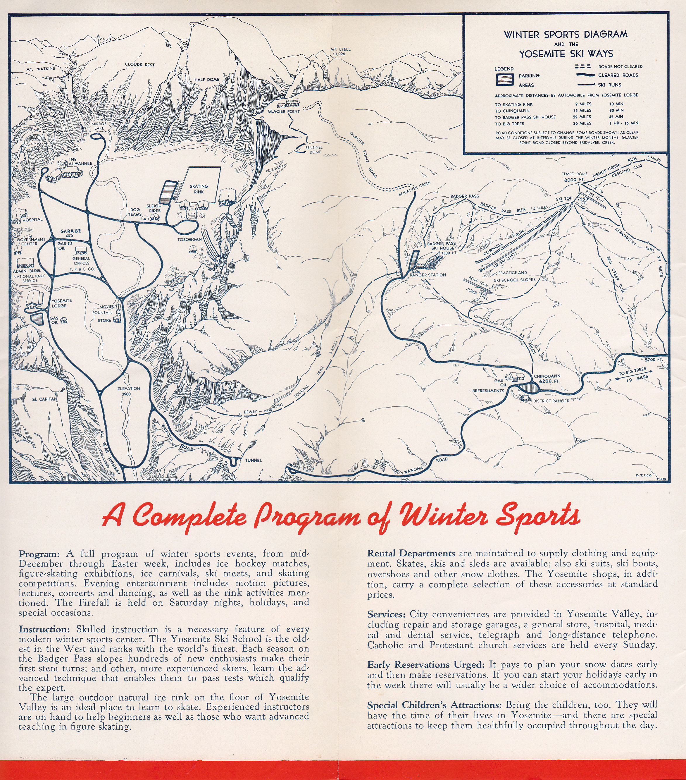
Historically, Badger Pass was part of the route of the original Glacier Point Road, constructed during 1882 and 1883. That unpaved primitive road went through the pass and ended directly 6.46 miles northeast at Glacier Point, at the rim of Yosemite Valley. Although a modern paved road now goes around the pass, the area retains its historical and ecological significance. The name "Badger Pass" reportedly originated from a stagecoach driver who spotted a badger while resting his horses in the area.[2]
About Badger Pass Ski Area
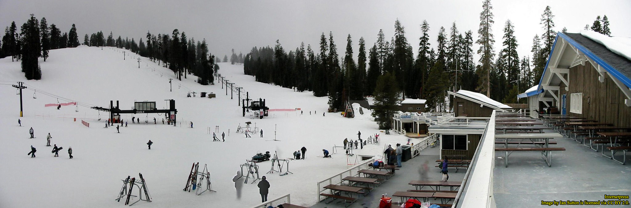
Badger Pass Ski Area is a 282-acre historic winter sports destination tucked within Yosemite National Park, offering a blend of timeless charm and modern amenities since its establishment in 1934.[3] Access is straightforward year-round, thanks to a paved road that is regularly cleared of snow, leading directly to a spacious 600-car parking lot. At the heart of the area stands its historic ski lodge, a welcoming hub where you can purchase lift tickets, enjoy a warm meal, find restrooms, browse a gift and clothing shop, host small gatherings in a meeting space, and connect with the ski operations offices. The lodge ensures a seamless experience both on and off the slopes.
Beyond the lodge, you’ll find ten historic downhill ski runs—each with its own unique landscape—interconnected by many “turkey trails” that make exploring the terrain simple and enjoyable. Five historic ski lifts provide a smooth ride uphill, and a ski school caters to learners of all ages, from children just beginning their winter adventures to adults refining their techniques. For those preferring quieter, scenic excursions, the area features, a historic snowshoe trail, a network of cross-country skiing trails, with two of them being historic, and a Nordic Center where cross-country skiing equipment may be rented. Two NASTAR Shacks also stand ready for visitors who crave a friendly taste of racing, allowing everyone to experience the thrill of competition.
As you take in all that Badger Pass has to offer, it’s easy to see why it remains a beloved winter haven. In the next section, we’ll help you pinpoint exactly where this memorable ski area lies within Yosemite, ensuring that you can plan your journey with confidence.
Where is Badger Pass Ski Area?
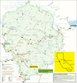
Although the lodge’s address is officially listed as 7062 Glacier Point Road in Yosemite National Park, the actual access point to Badger Pass Ski Area lies along a short spur known as Badger Pass Access Road, which branches off Glacier Point Road. About five miles from the intersection of Wawona Road and Glacier Point Road, you’ll reach the turnoff—though there is no dedicated signage here to alert you. Keep a careful eye on your route; the unobtrusive nature of the entry is intentional, preserving the authenticity of the landscape. Once you’ve found it, the 0.2-mile Badger Pass Access Road will guide you through a canopy of evergreens, framing a breathtaking approach to the lodge and ski area’s parking lots. From its earliest days, this careful design has enhanced visitors’ sense of arrival, making the journey part of the experience.
At the heart of this snowy retreat is Monroe Meadow, situated at the western end of the actual Badger Pass. This gently sloping meadow, named in honor of George Monroe—a Pony Express rider who bravely traveled between Merced and Mariposa—has a rich historical tapestry. In 1879, Monroe even drove President Ulysses S. Grant along what is now the Wawona Road, forging a connection between the country’s wild frontiers and its highest office.[4] Today, the Badger Pass Ski Lodge and its parking area rest at the meadow’s edge, seamlessly blending into the natural environment and offering an inspiring vantage point to begin your day’s activities.
Directions to Badger Pass Ski Area
Getting to Badger Pass Ski Area is a breeze, thanks to the convenience of modern mapping technology. Whether you're traveling from nearby cities or planning a journey from across the globe, you can easily create personalized directions to this historic ski destination.
To assist you, we’ve provided an interactive map titled “Directions to Badger Pass Ski Area.” This map allows you to generate a set of directions from practically any location on Earth to the Badger Pass Ski Lodge, which is marked with a white dotted blue balloon for easy identification.
To create your own directions:
- Start by going to the interactive map, that follows this procedure, and is titled Badger Pass Ski Area, Yosemite National Park.
- Select the dotted blue balloon, that marks the lodge, to open its description panel.
- At the top of the panel is a red area. At the right side of that area, select the diamond, containing an arrow pointing to the right, to open a new tab that presents you another map. In that new map, the lodge will be marked with a red balloon.
- Use the provided text box for typing in a starting city, town, or address.
- Press Enter to produce your directions and plot a route on that map.
Hours of Operation
Badger Pass Ski Area operates under a contract agreement with the National Park Service but is not directly managed by it. Instead, its operation is handled by a designated park concessioner, which, as of 2025, is Yosemite Hospitality, LLC—a subsidiary of Aramark Destinations. The ski area is only open during the winter season and only when there is enough snow. While the typical season runs from December 13th to March 31st, actual opening and closing dates depend entirely on snow conditions, as determined by ski area management.
Yosemite Hospitality provides the most up-to-date information on operating status and snow conditions through its website, TravelYosemite.com, and through the “Snow Phone” at (209) 372-1000, which plays a recorded message about current conditions. For direct inquiries, you can call Aramark Destinations at (888) 413-8869 and ask for information regarding Badger Pass. When open, the ski lodge operates daily from 8:30 AM to 4:00 PM, providing apline ski equipment rentals, locker rentals, food service, and ticket sales. The Nordic Center's number, where cross-country skiing equipment rentals are located, is (209) 372-4996. The ski lifts generally run from 9:00 AM to 4:00 PM.
Access when the Ski Area is Closed
Access to Badger Pass is via Glacier Point Road, but when the ski area is closed, the road may also be closed. A gate, located about 320 feet (97 m) from the intersection with Wawona Road (State Route 41), may prevent vehicle access. If the ski area is closed, visitors seeking to enter the surrounding area for cross-country skiing or snowshoeing must park at the intersection of Wawona Road and Glacier Point Road and then either ski or snowshoe along the closed Glacier Point Road or use the Chinquapin trail. The Chinquapin trailhead is located behind the parking lot. Be aware that the Chinquapin trail requires stamina and strength due to its length and rise in elevation, and overnight stays require a wilderness permit. There is also a gate at the entrance to the Ski Area parking lot that will probably be locked when the ski area is closed. Further details on downhill and cross-country skiing are covered in another article in this series.
Footnotes
- ^ Page & Turnbull, Inc., Badger Pass Ski Area Cultural landscape Report (2010), pg. 1. https://issuu.com/page-turnbull/docs/badger_pass_clr.
- ^ Pat Oliver, "How did Badger Pass get its name? And other interesting tidbits," Yosemite Collector and Historical Quarterly (n.d.): pg. 7.
- ^ Page & Turnbull, Inc., Badger Pass Ski Area Cultural landscape Report (2010), pg. 3. https://issuu.com/page-turnbull/docs/badger_pass_clr.
- ^ Miriam Matthews Photograph Collection, George Monroe, stagecoach driver, circa 1870-1886, UCLA, Library Special Collections, Charles E. Young Research Library. https://calisphere.org/item/ark:/21198/z1j690w0/.